san rafael swell trails
Things to Note:
RIDE DIFFICULTY DEFINITIONS:
- PLEASE NOTE THAT YOU MUST TRAILER YOUR OWN ATV/UTV TO THE SELECT TRAILHEAD/STAGING AREA (SEE RIDE DESCRIPTIONS)
- Each participant must be responsible for his/her own health and well-being along the trail. If you have particular medical or physical limitations, but decide to go anyway, please make your guide aware of your condition.
- ATV trails are not intended for high speed riding. It is necessary that all participants stay with the group, remaining behind the front guide at all times, for the safety and peace of mind of the entire group. ATVs/UTVs must be in good mechanical condition.
- Trails are subject to change
RIDE DIFFICULTY DEFINITIONS:
- BEGINNER: These rides are almost wholly on maintained dirt roads. Some of the beginner rides may include short moderately steep sections or switchbacks.
- INTERMEDIATE: Intermediate rides generally include some road and ATV trail portions with some steep, rough or challenging trails.
- ADVANCED: Advanced rides will generally include portions that are steep, rough, and otherwise difficult to maneuver.
THURSDAY
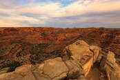
buckhorn indian panel & little grand canyon
RIDE DIFFICULTY: Beginner
OHV Size Limitation: None
Approximate Mileage: 60
Staging Area: Must trailer to
Departure: 8:00 AM
This ride begins at the Buckhorn Information Center. From there, you will travel to the Wedge Overlook trail for a view of the 'Little Grand Canyon'. You will then head down into Buckhorn Draw to view a dinosaur track, the Buckhorn Panel, and the Swinging Bridge that spans the San Rafael River. From there, you will travel out of Buckhorn Wash and head to Furniture Draw to the Historic Chinese Railroad. You will then head back to the Buckhorn Information Center.
FRIDAY
COPPER GLOBE
RIDE DIFFICULTY: Beginner/Intermediate
OHV Size Limitation: 70"
Approximate Mileage: 50 miles
Staging Area: MUST TRAILER TO
Trail Head Location: 38.859202 N, 110.916821 W
Departure: 8:00 AM
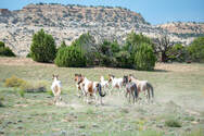
The Copper Globe Mine ride will be south of I-70. We will trailer from Ferron to I-70 (Moore Cutoff Road) exit 116; staging area in the vicinity of the county gravel pit. From there our ride will take us through some flat land trails, passing over I-70 to Cat Canyon and across Link Flats. This part of the trail leads to a couple of overlooks, one being that of the Lucky Strike Mine area and the other is called “Picture Window” – this is where we will have lunch (both overlooks, provide scenery into the Reds Canyon area). As we continue to travel towards the Copper Globe Mine, there is possible wild horse sightings, so be on the lookout. The trail goes through some slick rock terrain, all easy to maneuver.
Upon arrival to Copper Globe, there is an historical grave side you will stop at before actually entering the mine area. The Copper Globe Mine operating area basically horseshoes around a slick rock mountain formation, where you will see several structures to include an old shed and living quarters. There are also mine shafts of which are protected by fences or rebar. While in this area, there is some easy hiking required to see certain parts of the mine. Upon departure from this site, you will head back to the staging area, passing through Justensen Flats. This is one of the San Rafael Swells signature-historical rides.
OHV Size Limitation: 70"
Approximate Mileage: 50 miles
Staging Area: MUST TRAILER TO
Trail Head Location: 38.859202 N, 110.916821 W
Departure: 8:00 AM
The Copper Globe Mine ride will be south of I-70. We will trailer from Ferron to I-70 (Moore Cutoff Road) exit 116; staging area in the vicinity of the county gravel pit. From there our ride will take us through some flat land trails, passing over I-70 to Cat Canyon and across Link Flats. This part of the trail leads to a couple of overlooks, one being that of the Lucky Strike Mine area and the other is called “Picture Window” – this is where we will have lunch (both overlooks, provide scenery into the Reds Canyon area). As we continue to travel towards the Copper Globe Mine, there is possible wild horse sightings, so be on the lookout. The trail goes through some slick rock terrain, all easy to maneuver.
Upon arrival to Copper Globe, there is an historical grave side you will stop at before actually entering the mine area. The Copper Globe Mine operating area basically horseshoes around a slick rock mountain formation, where you will see several structures to include an old shed and living quarters. There are also mine shafts of which are protected by fences or rebar. While in this area, there is some easy hiking required to see certain parts of the mine. Upon departure from this site, you will head back to the staging area, passing through Justensen Flats. This is one of the San Rafael Swells signature-historical rides.